Fog Dam walks
- Distance: 1.3 mi
- Elevation gain: 23 ft
- Maximum elevation: 39 ft
- Elevation loss: 20 ft
- Minimum elevation: 23 ft
- Moving time: 43 m 11 s
- Moving speed: 1.7 mph
- Maximum speed: 9.8 mph
- Total time: 1 h 20 m
- Global speed: 0.9 mph
Interactive trail map
Trail profile
- Distance: 1.3 mi
- Elevation gain: 23 ft
- Maximum elevation: 39 ft
- Elevation loss: 20 ft
- Minimum elevation: 23 ft
- Moving time: 43 m 11 s
- Moving speed: 1.7 mph
- Maximum speed: 9.8 mph
- Total time: 1 h 20 m
- Global speed: 0.9 mph
About this trail
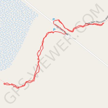
Name: Fog Dam walks trail, distance, elevation, map, profile, GPS track
Coordinates: -12.57033 131.30541 -12.56676 131.31073
Other hiking, mountain biking, running and outdoor activity trails
Click on a trail to view its statistics, map and profile.
Fogg Dam Monsoon Walk
Australia > Litchfield Municipality > Middle Point
Distance: 1.3 mi • Elevation gain: 33 ft • Maximum elevation: 62 ft