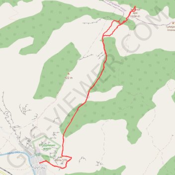
Trenutna trasa: 13 SRP 2019 13:42
- Distance: 7.8 mi
- Elevation gain: 3,684 ft
- Maximum elevation: 4,344 ft
- Elevation loss: 3,684 ft
- Minimum elevation: 896 ft
- Moving time: 4 h 24 m
- Moving speed: 1.8 mph
- Maximum speed: 4.6 mph
- Total time: 5 h 4 m
- Global speed: 1.5 mph
Interactive trail map
Trail profile
- Distance: 7.8 mi
- Elevation gain: 3,684 ft
- Maximum elevation: 4,344 ft
- Elevation loss: 3,684 ft
- Minimum elevation: 896 ft
- Moving time: 4 h 24 m
- Moving speed: 1.8 mph
- Maximum speed: 4.6 mph
- Total time: 5 h 4 m
- Global speed: 1.5 mph
About this trail
Name: Trenutna trasa: 13 SRP 2019 13:42 trail, distance, elevation, map, profile, GPS track
Coordinates: 43.29398 22.22344 43.33044 22.25308