Thank you for supporting this site ❤️
Make a donation
Make a donation
Gear up for your next adventure:
As an Amazon Associate, this site earns from qualifying purchases at no extra cost to you.
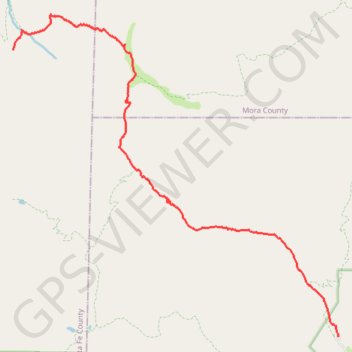
Cave Creek and Skyline trails
Pecos Wilderness hike
- Distance: 8.3 mi
- Elevation gain: 3,087 ft
- Maximum elevation: 10,830 ft
- Elevation loss: 879 ft
- Minimum elevation: 8,360 ft
- Moving time: 4 h 31 m
- Moving speed: 1.8 mph
- Maximum speed: 3.6 mph
- Total time: 6 h 10 m
- Global speed: 1.3 mph
Interactive trail map
Thank you for supporting this site ❤️
Make a donation
Make a donation
Gear up for your next adventure:
As an Amazon Associate, this site earns from qualifying purchases at no extra cost to you.
Trail profile
- Distance: 8.3 mi
- Elevation gain: 3,087 ft
- Maximum elevation: 10,830 ft
- Elevation loss: 879 ft
- Minimum elevation: 8,360 ft
- Moving time: 4 h 31 m
- Moving speed: 1.8 mph
- Maximum speed: 3.6 mph
- Total time: 6 h 10 m
- Global speed: 1.3 mph
Thank you for supporting this site ❤️
Make a donation
Make a donation
Gear up for your next adventure:
As an Amazon Associate, this site earns from qualifying purchases at no extra cost to you.
About this trail
Name: Cave Creek and Skyline trails trail, distance, elevation, map, profile, GPS track
End: Redondo Peak Trail, Santa Fe County, New Mexico, United States (35.88316 -105.73860)
Coordinates: 35.82992 -105.73862 35.88963 -105.66418
Topography: San Miguel County topographic map, elevation, terrain
Thank you for supporting this site ❤️
Make a donation
Make a donation
Gear up for your next adventure:
As an Amazon Associate, this site earns from qualifying purchases at no extra cost to you.