Thank you for supporting this site ❤️
Make a donation
Make a donation
Gear up for your next adventure:
As an Amazon Associate, this site earns from qualifying purchases at no extra cost to you.
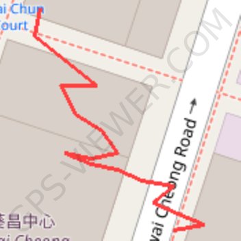
Modified_gnsstestingresult_npm1300ldo_20240618d
- Distance: 0.1 mi
- Elevation gain: 33 ft
- Maximum elevation: 112 ft
- Elevation loss: 0 ft
- Minimum elevation: 79 ft
- Moving time: 2 m 37 s
- Moving speed: 1.5 mph
- Maximum speed: 7.8 mph
- Total time: 5 m 59 s
- Global speed: 0.6 mph
Interactive trail map
Thank you for supporting this site ❤️
Make a donation
Make a donation
Gear up for your next adventure:
As an Amazon Associate, this site earns from qualifying purchases at no extra cost to you.
Trail profile
- Distance: 0.1 mi
- Elevation gain: 33 ft
- Maximum elevation: 112 ft
- Elevation loss: 0 ft
- Minimum elevation: 79 ft
- Moving time: 2 m 37 s
- Moving speed: 1.5 mph
- Maximum speed: 7.8 mph
- Total time: 5 m 59 s
- Global speed: 0.6 mph
Thank you for supporting this site ❤️
Make a donation
Make a donation
Gear up for your next adventure:
As an Amazon Associate, this site earns from qualifying purchases at no extra cost to you.
About this trail
Name: Modified_gnsstestingresult_npm1300ldo_20240618d trail, distance, elevation, map, profile, GPS track
Coordinates: 22.36382 114.13275 22.36422 114.13308
Thank you for supporting this site ❤️
Make a donation
Make a donation
Gear up for your next adventure:
As an Amazon Associate, this site earns from qualifying purchases at no extra cost to you.
Other hiking, mountain biking, running and outdoor activity trails
Click on a trail to view its statistics, map and profile.
麦理浩径
China > Hong Kong > Sai Kung District > Tsak Yue Wu
北潭涌至屯门
Distance: 61.3 mi • Elevation gain: 16,886 ft • Maximum elevation: 3,031 ft