Make a donation
Gear up for your next adventure:
As an Amazon Associate, this site earns from qualifying purchases at no extra cost to you.
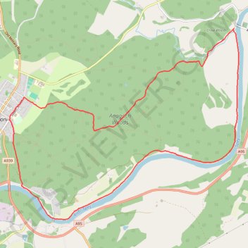
Grantown on Spey, loop in the forest and along the river Spey
Interactive trail map
Make a donation
Gear up for your next adventure:
As an Amazon Associate, this site earns from qualifying purchases at no extra cost to you.
Trail profile
- Distance: 6.7 mi
- Elevation gain: 230 ft
- Maximum elevation: 719 ft
- Elevation loss: 230 ft
- Minimum elevation: 591 ft
- Moving time: 2 h 43 m
- Moving speed: 2.5 mph
- Maximum speed: 4.6 mph
- Total time: 2 h 45 m
- Global speed: 2.4 mph
Make a donation
Gear up for your next adventure:
As an Amazon Associate, this site earns from qualifying purchases at no extra cost to you.
About this trail
Name: Grantown on Spey, loop in the forest and along the river Spey trail, distance, elevation, map, profile, GPS track
Start: Forest Road, Grantown-on-Spey, Highland, Scotland, PH26 3JL, United Kingdom (57.32982 -3.60599)
End: Forest Road, Grantown-on-Spey, Highland, Scotland, PH26 3JL, United Kingdom (57.32980 -3.60600)
Coordinates: 57.31747 -3.60600 57.34117 -3.55326
Make a donation
Gear up for your next adventure:
As an Amazon Associate, this site earns from qualifying purchases at no extra cost to you.
Other hiking, mountain biking, running and outdoor activity trails
Click on a trail to view its statistics, map and profile.
Tracks in Docharn forest and surrounding
United Kingdom > Scotland > Highland > Grantown-on-Spey
Highlands Gravel/Unpaved Cycling
Distance: 28.2 mi • Elevation gain: 1,877 ft • Maximum elevation: 1,112 ft