Ledges Trail hike
- Distance: 3.3 mi
- Elevation gain: 354 ft
- Maximum elevation: 1,056 ft
- Elevation loss: 325 ft
- Minimum elevation: 886 ft
- Moving time: 1 h 25 m
- Moving speed: 2.3 mph
- Maximum speed: 14.7 mph
- Total time: 1 h 59 m
- Global speed: 1.7 mph
Interactive trail map
Trail profile
- Distance: 3.3 mi
- Elevation gain: 354 ft
- Maximum elevation: 1,056 ft
- Elevation loss: 325 ft
- Minimum elevation: 886 ft
- Moving time: 1 h 25 m
- Moving speed: 2.3 mph
- Maximum speed: 14.7 mph
- Total time: 1 h 59 m
- Global speed: 1.7 mph
About this trail
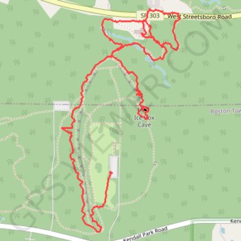
Name: Ledges Trail hike trail, distance, elevation, map, profile, GPS track
End: Ledges Trail, Boston Township, Summit County, Ohio, 44264, United States (41.22271 -81.51078)
Coordinates: 41.21946 -81.51428 41.23147 -81.50586
Topography: Summit County topographic map, elevation, terrain
Other hiking, mountain biking, running and outdoor activity trails
Click on a trail to view its statistics, map and profile.
Pine Grove Trail and Ledges Trail Loop from Kendall Lake in Cuyahoga Valley National Park
United States > Ohio > Summit County > Peninsula
The Pine Grove Trail and Ledges Trail Loop from Kendall Lake offers a delightful blend of scenic views and diverse landscapes. Hikers will traverse through lush forests filled with towering pines and hemlocks, and experience striking rock formations, particularly at the Ledges Overlook, which provides a…
Distance: 4.3 mi • Elevation gain: 331 ft • Maximum elevation: 1,037 ft
Pine Grove Trail and Ledges Trail Loop in Cuyahoga Valley National Park
United States > Ohio > Summit County
The Pine Grove and Ledges Trails Loop offers a serene blend of forested paths, rocky outcrops, and dramatic sandstone formations. Starting from Kendall Lake, the hike transitions from the quiet tranquility of the Pine Grove Trail's wooded sections to the rugged beauty of the Ledges Trail, where massive rock…
Distance: 4.2 mi • Elevation gain: 318 ft • Maximum elevation: 1,037 ft
Ledges Loop Trail in Cuyahoga Valley National Park
United States > Ohio > Summit County
The Ledges Loop Trail offers a captivating hiking experience characterized by towering sandstone cliffs and lush hardwood forests. Along the trail, you'll encounter unique geological features, including intriguing rock formations with honeycomb-like patterns, as well as vibrant wildlife such as chipmunks and…
Distance: 2.4 mi • Elevation gain: 144 ft • Maximum elevation: 1,053 ft