Make a donation
Gear up for your next adventure:
As an Amazon Associate, this site earns from qualifying purchases at no extra cost to you.
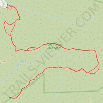
Fond Family Open Space forgotten trail
- Distance: 3.8 mi
- Elevation gain: 991 ft
- Maximum elevation: 1,844 ft
- Elevation loss: 991 ft
- Minimum elevation: 1,191 ft
- Moving time: 1 h 36 m
- Moving speed: 2.3 mph
- Maximum speed: 7.3 mph
- Total time: 1 h 51 m
- Global speed: 2.0 mph
Interactive trail map
Make a donation
Gear up for your next adventure:
As an Amazon Associate, this site earns from qualifying purchases at no extra cost to you.
Trail profile
- Distance: 3.8 mi
- Elevation gain: 991 ft
- Maximum elevation: 1,844 ft
- Elevation loss: 991 ft
- Minimum elevation: 1,191 ft
- Moving time: 1 h 36 m
- Moving speed: 2.3 mph
- Maximum speed: 7.3 mph
- Total time: 1 h 51 m
- Global speed: 2.0 mph
Make a donation
Gear up for your next adventure:
As an Amazon Associate, this site earns from qualifying purchases at no extra cost to you.
About this trail
Name: Fond Family Open Space forgotten trail trail, distance, elevation, map, profile, GPS track
Coordinates: 34.24233 -118.34012 34.25119 -118.32925
Topography: Los Angeles topographic map, elevation, terrain
Make a donation
Gear up for your next adventure:
As an Amazon Associate, this site earns from qualifying purchases at no extra cost to you.
Other hiking, mountain biking, running and outdoor activity trails
Click on a trail to view its statistics, map and profile.
Fond Family Open Space
United States > California > Los Angeles County > Los Angeles
Distance: 4.7 mi • Elevation gain: 1,073 ft • Maximum elevation: 1,844 ft