Make a donation
Gear up for your next adventure:
As an Amazon Associate, this site earns from qualifying purchases at no extra cost to you.
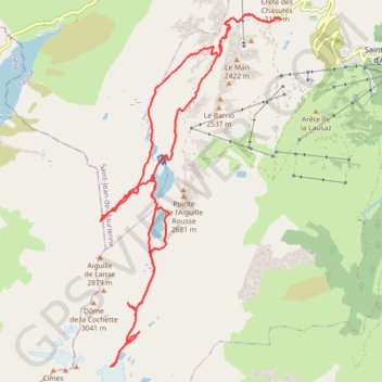
Rando découverte : refuge de l'étendard, glacier de Saint Sorlin et recherche d'une brèche dans les massifs rocheux afin de pouvoir y aller depuis l'alpe d'Huez lors d'une prochaine expédition. Retour à la voiture juste avant la tombée de nuit après s'êt
- Distance: 16.3 mi
- Elevation gain: 4,482 ft
- Maximum elevation: 8,983 ft
- Elevation loss: 4,478 ft
- Minimum elevation: 6,749 ft
- Moving time: 7 h 12 m
- Moving speed: 2.3 mph
- Maximum speed: 20.3 mph
- Total time: 9 h 21 m
- Global speed: 1.7 mph
Interactive trail map
Make a donation
Gear up for your next adventure:
As an Amazon Associate, this site earns from qualifying purchases at no extra cost to you.
Trail profile
- Distance: 16.3 mi
- Elevation gain: 4,482 ft
- Maximum elevation: 8,983 ft
- Elevation loss: 4,478 ft
- Minimum elevation: 6,749 ft
- Moving time: 7 h 12 m
- Moving speed: 2.3 mph
- Maximum speed: 20.3 mph
- Total time: 9 h 21 m
- Global speed: 1.7 mph
Make a donation
Gear up for your next adventure:
As an Amazon Associate, this site earns from qualifying purchases at no extra cost to you.
About this trail
Name: Rando découverte : refuge de l'étendard, glacier de Saint Sorlin et recherche d'une brèche dans les massifs rocheux afin de pouvoir y aller depuis l'alpe d'Huez lors d'une prochaine expédition. Retour à la voiture juste avant la tombée de nuit après s'êt trail, distance, elevation, map, profile, GPS track
Coordinates: 45.16877 6.16069 45.22814 6.20407
Make a donation
Gear up for your next adventure:
As an Amazon Associate, this site earns from qualifying purchases at no extra cost to you.
Other hiking, mountain biking, running and outdoor activity trails
Click on a trail to view its statistics, map and profile.
Trail de l’Étendard - 44km
France > Auvergne-Rhône-Alpes > Isère > Le Bourg-d'Oisans > Le Bassey
Distance: 28.0 mi • Elevation gain: 10,367 ft • Maximum elevation: 8,944 ft
PT23DS2 Lörrach → Cadaqués
Germany > Baden-Württemberg > Landkreis Lörrach > Lörrach (Kernstadt)
Distance: 652.9 mi • Elevation gain: 43,077 ft • Maximum elevation: 4,938 ft