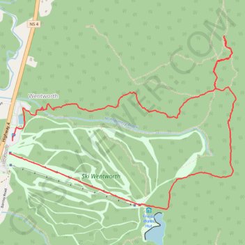
Wentworth Festival of Colors
Hiked to High Head and Down Mountain.
- Distance: 4.3 mi
- Elevation gain: 942 ft
- Maximum elevation: 971 ft
- Elevation loss: 945 ft
- Minimum elevation: 177 ft
- Moving time: 1 h 59 m
- Moving speed: 2.1 mph
- Maximum speed: 5.1 mph
- Total time: 2 h 35 m
- Global speed: 1.7 mph
Interactive trail map
Trail profile
- Distance: 4.3 mi
- Elevation gain: 942 ft
- Maximum elevation: 971 ft
- Elevation loss: 945 ft
- Minimum elevation: 177 ft
- Moving time: 1 h 59 m
- Moving speed: 2.1 mph
- Maximum speed: 5.1 mph
- Total time: 2 h 35 m
- Global speed: 1.7 mph
About this trail
Name: Wentworth Festival of Colors trail, distance, elevation, map, profile, GPS track
Coordinates: 45.60558 -63.56127 45.61840 -63.53733
Other hiking, mountain biking, running and outdoor activity trails
Click on a trail to view its statistics, map and profile.
Amherst - Brookfield
Canada > Nova Scotia > Municipality of the County of Cumberland > Upper Nappan
Distance: 75.4 mi • Elevation gain: 3,343 ft • Maximum elevation: 837 ft