Make a donation
Gear up for your next adventure:
As an Amazon Associate, this site earns from qualifying purchases at no extra cost to you.
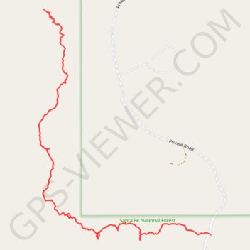
Potential route around GS camp in the Santa Fe National Forest
- Distance: 1.3 mi
- Elevation gain: 128 ft
- Maximum elevation: 8,107 ft
- Elevation loss: 358 ft
- Minimum elevation: 7,785 ft
- Moving time: 47 m 7 s
- Moving speed: 1.7 mph
- Maximum speed: 14.5 mph
- Total time: 1 h 26 m
- Global speed: 0.9 mph
Interactive trail map
Make a donation
Gear up for your next adventure:
As an Amazon Associate, this site earns from qualifying purchases at no extra cost to you.
Trail profile
- Distance: 1.3 mi
- Elevation gain: 128 ft
- Maximum elevation: 8,107 ft
- Elevation loss: 358 ft
- Minimum elevation: 7,785 ft
- Moving time: 47 m 7 s
- Moving speed: 1.7 mph
- Maximum speed: 14.5 mph
- Total time: 1 h 26 m
- Global speed: 0.9 mph
Make a donation
Gear up for your next adventure:
As an Amazon Associate, this site earns from qualifying purchases at no extra cost to you.
About this trail
Name: Potential route around GS camp in the Santa Fe National Forest trail, distance, elevation, map, profile, GPS track
Start: Private Road, Sandoval County, New Mexico, United States (35.88512 -106.80874)
End: Forest Road 539, O'Neil Landing, Sandoval County, New Mexico, United States (35.87712 -106.80140)
Coordinates: 35.87692 -106.80893 35.88512 -106.80140
Topography: Sandoval County topographic map, elevation, terrain
Make a donation
Gear up for your next adventure:
As an Amazon Associate, this site earns from qualifying purchases at no extra cost to you.
Other hiking, mountain biking, running and outdoor activity trails
Click on a trail to view its statistics, map and profile.
Jemez MTB ride
United States > New Mexico > Sandoval County > O'Neil Landing
Lunch Mountain Bike Ride
Distance: 16.3 mi • Elevation gain: 2,828 ft • Maximum elevation: 9,049 ft