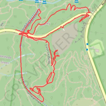
Afternoon Walk
- Distance: 2.6 mi
- Elevation gain: 312 ft
- Maximum elevation: 348 ft
- Elevation loss: 299 ft
- Minimum elevation: 174 ft
- Moving time: 1 h 4 m
- Moving speed: 2.4 mph
- Maximum speed: 4.3 mph
- Total time: 1 h 13 m
- Global speed: 2.1 mph
Interactive trail map
Trail profile
- Distance: 2.6 mi
- Elevation gain: 312 ft
- Maximum elevation: 348 ft
- Elevation loss: 299 ft
- Minimum elevation: 174 ft
- Moving time: 1 h 4 m
- Moving speed: 2.4 mph
- Maximum speed: 4.3 mph
- Total time: 1 h 13 m
- Global speed: 2.1 mph
About this trail
Name: Afternoon Walk trail, distance, elevation, map, profile, GPS track
Coordinates: -32.99612 151.70776 -32.98996 151.71335
Other hiking, mountain biking, running and outdoor activity trails
Click on a trail to view its statistics, map and profile.
Broadmeadow - Readhead Beach - Belmont
Australia > New South Wales > Newcastle-Maitland
Fernleigh Track. #Bike
Distance: 22.8 mi • Elevation gain: 866 ft • Maximum elevation: 322 ft
Fernleigh Rail Trail
Australia > New South Wales > Newcastle-Maitland > Belmont
#Bike
Distance: 13.1 mi • Elevation gain: 525 ft • Maximum elevation: 322 ft
Oakdale Quarry trails
Australia > New South Wales > Newcastle-Maitland
Distance: 4.2 mi • Elevation gain: 433 ft • Maximum elevation: 285 ft
Oakdale quarry
Australia > New South Wales > Newcastle-Maitland
Distance: 2.7 mi • Elevation gain: 285 ft • Maximum elevation: 348 ft