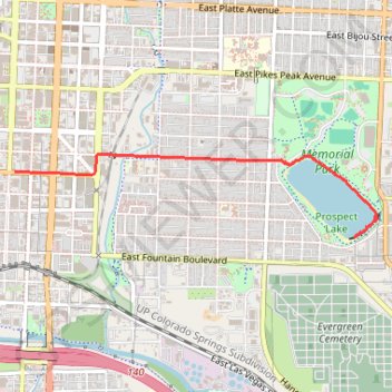
Thank you for supporting this site ❤️
Make a donation
Make a donation
Gear up for your next adventure:
As an Amazon Associate, this site earns from qualifying purchases at no extra cost to you.
Memorial Park
- Distance: 2.0 mi
- Elevation gain: 49 ft
- Maximum elevation: 6,089 ft
- Elevation loss: 138 ft
- Minimum elevation: 5,965 ft
- Moving time: 25 m 41 s
- Moving speed: 4.8 mph
- Maximum speed: 29.4 mph
- Total time: 26 m 35 s
- Global speed: 4.6 mph
Interactive trail map
Thank you for supporting this site ❤️
Make a donation
Make a donation
Gear up for your next adventure:
As an Amazon Associate, this site earns from qualifying purchases at no extra cost to you.
Trail profile
- Distance: 2.0 mi
- Elevation gain: 49 ft
- Maximum elevation: 6,089 ft
- Elevation loss: 138 ft
- Minimum elevation: 5,965 ft
- Moving time: 25 m 41 s
- Moving speed: 4.8 mph
- Maximum speed: 29.4 mph
- Total time: 26 m 35 s
- Global speed: 4.6 mph
Thank you for supporting this site ❤️
Make a donation
Make a donation
Gear up for your next adventure:
As an Amazon Associate, this site earns from qualifying purchases at no extra cost to you.
About this trail
Name: Memorial Park trail, distance, elevation, map, profile, GPS track
Coordinates: 38.82267 -104.82521 38.82805 -104.79502
Topography: Colorado Springs topographic map, elevation, terrain
Thank you for supporting this site ❤️
Make a donation
Make a donation
Gear up for your next adventure:
As an Amazon Associate, this site earns from qualifying purchases at no extra cost to you.