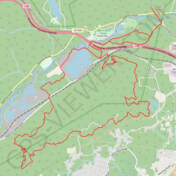
Allamuchy Mountain State Park
- Distance: 17.1 mi
- Elevation gain: 1,457 ft
- Maximum elevation: 1,165 ft
- Elevation loss: 1,457 ft
- Minimum elevation: 630 ft
- Moving time: 3 h 1 m
- Moving speed: 5.7 mph
- Maximum speed: 17.5 mph
- Total time: 3 h 13 m
- Global speed: 5.3 mph
Interactive trail map
Trail profile
- Distance: 17.1 mi
- Elevation gain: 1,457 ft
- Maximum elevation: 1,165 ft
- Elevation loss: 1,457 ft
- Minimum elevation: 630 ft
- Moving time: 3 h 1 m
- Moving speed: 5.7 mph
- Maximum speed: 17.5 mph
- Total time: 3 h 13 m
- Global speed: 5.3 mph
About this trail
Name: Allamuchy Mountain State Park trail, distance, elevation, map, profile, GPS track
Coordinates: 40.88106 -74.78582 40.92258 -74.73580
Topography: Byram Township topographic map, elevation, terrain
Other hiking, mountain biking, running and outdoor activity trails
Click on a trail to view its statistics, map and profile.
Allamuchy E-Mountain Bike Ride
United States > New Jersey > Morris County > Mount Olive
Allamuchy Mountain
Distance: 16.8 mi • Elevation gain: 1,785 ft • Maximum elevation: 1,217 ft
Stephens State Park
United States > New Jersey > Sussex County > Byram Township
Distance: 21.5 mi • Elevation gain: 2,257 ft • Maximum elevation: 1,178 ft
Best Of Deer Park
United States > New Jersey > Morris County > Mount Olive
Distance: 19.8 mi • Elevation gain: 2,037 ft • Maximum elevation: 1,119 ft