Make a donation
Gear up for your next adventure:
As an Amazon Associate, this site earns from qualifying purchases at no extra cost to you.
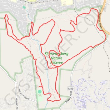
Klipriviersburg Nature Reserve Loop
- Distance: 12.3 mi
- Elevation gain: 2,234 ft
- Maximum elevation: 5,863 ft
- Elevation loss: 2,234 ft
- Minimum elevation: 5,069 ft
- Moving time: 2 h 24 m
- Moving speed: 5.1 mph
- Maximum speed: 9.6 mph
- Total time: 2 h 35 m
- Global speed: 4.7 mph
Interactive trail map
Make a donation
Gear up for your next adventure:
As an Amazon Associate, this site earns from qualifying purchases at no extra cost to you.
Trail profile
- Distance: 12.3 mi
- Elevation gain: 2,234 ft
- Maximum elevation: 5,863 ft
- Elevation loss: 2,234 ft
- Minimum elevation: 5,069 ft
- Moving time: 2 h 24 m
- Moving speed: 5.1 mph
- Maximum speed: 9.6 mph
- Total time: 2 h 35 m
- Global speed: 4.7 mph
Make a donation
Gear up for your next adventure:
As an Amazon Associate, this site earns from qualifying purchases at no extra cost to you.
About this trail
Name: Klipriviersburg Nature Reserve Loop trail, distance, elevation, map, profile, GPS track
Coordinates: -26.30820 28.00014 -26.27947 28.03524
Make a donation
Gear up for your next adventure:
As an Amazon Associate, this site earns from qualifying purchases at no extra cost to you.
Other hiking, mountain biking, running and outdoor activity trails
Click on a trail to view its statistics, map and profile.
Klipriviersburg Nature Reserve loop
South Africa > Gauteng > City of Johannesburg Metropolitan Municipality > Johannesburg
Distance: 10.8 mi • Elevation gain: 2,041 ft • Maximum elevation: 5,863 ft
Klipriviersberg Nature Reserve loop
South Africa > Gauteng > City of Johannesburg Metropolitan Municipality > Johannesburg
Distance: 8.5 mi • Elevation gain: 1,640 ft • Maximum elevation: 5,863 ft