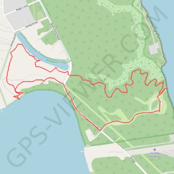
Long Pond and Happy Marsh loop trail in Widewater State Park
- Distance: 2.6 mi
- Elevation gain: 131 ft
- Maximum elevation: 36 ft
- Elevation loss: 131 ft
- Minimum elevation: -3 ft
- Moving time: 1 h 31 m
- Moving speed: 1.7 mph
- Maximum speed: 2.4 mph
- Total time: 1 h 54 m
- Global speed: 1.4 mph
Interactive trail map
Trail profile
- Distance: 2.6 mi
- Elevation gain: 131 ft
- Maximum elevation: 36 ft
- Elevation loss: 131 ft
- Minimum elevation: -3 ft
- Moving time: 1 h 31 m
- Moving speed: 1.7 mph
- Maximum speed: 2.4 mph
- Total time: 1 h 54 m
- Global speed: 1.4 mph
About this trail
Name: Long Pond and Happy Marsh loop trail in Widewater State Park trail, distance, elevation, map, profile, GPS track
Coordinates: 38.40502 -77.32824 38.41056 -77.31502
Topography: Stafford County topographic map, elevation, terrain