Woodpecker Hill Loop Trail
Afternoon Trail Run
- Distance: 1.4 mi
- Elevation gain: 154 ft
- Maximum elevation: 984 ft
- Elevation loss: 151 ft
- Minimum elevation: 853 ft
- Moving time: 17 m 59 s
- Moving speed: 4.7 mph
- Maximum speed: 7.7 mph
- Total time: 18 m 36 s
- Global speed: 4.6 mph
Interactive trail map
Trail profile
- Distance: 1.4 mi
- Elevation gain: 154 ft
- Maximum elevation: 984 ft
- Elevation loss: 151 ft
- Minimum elevation: 853 ft
- Moving time: 17 m 59 s
- Moving speed: 4.7 mph
- Maximum speed: 7.7 mph
- Total time: 18 m 36 s
- Global speed: 4.6 mph
About this trail
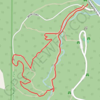
Name: Woodpecker Hill Loop Trail trail, distance, elevation, map, profile, GPS track
Start: White Oak Shelter, White Oaks, Linn County, Iowa, United States (42.21600 -91.54286)
End: Service drive, Linn County, Iowa, United States (42.21589 -91.54318)
Coordinates: 42.21042 -91.54898 42.21600 -91.54286
Topography: Linn County topographic map, elevation, terrain
Other hiking, mountain biking, running and outdoor activity trails
Click on a trail to view its statistics, map and profile.
MTB Loop ride in Pinicon Ridge County Park
United States > Iowa > Linn County
Distance: 6.8 mi • Elevation gain: 623 ft • Maximum elevation: 997 ft