Newark Park Loop Walk
- Distance: 2.6 mi
- Elevation gain: 476 ft
- Maximum elevation: 732 ft
- Elevation loss: 476 ft
- Minimum elevation: 289 ft
- Moving time: 2 h 22 m
- Moving speed: 1.1 mph
- Maximum speed: 3.6 mph
- Total time: 3 h 27 m
- Global speed: 0.7 mph
Interactive trail map
Trail profile
- Distance: 2.6 mi
- Elevation gain: 476 ft
- Maximum elevation: 732 ft
- Elevation loss: 476 ft
- Minimum elevation: 289 ft
- Moving time: 2 h 22 m
- Moving speed: 1.1 mph
- Maximum speed: 3.6 mph
- Total time: 3 h 27 m
- Global speed: 0.7 mph
About this trail
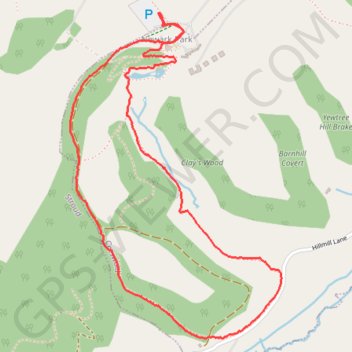
Name: Newark Park Loop Walk trail, distance, elevation, map, profile, GPS track
Coordinates: 51.62649 -2.32301 51.63752 -2.31146
Other hiking, mountain biking, running and outdoor activity trails
Click on a trail to view its statistics, map and profile.
Dean2023-311
United Kingdom > England > Oxfordshire > Oxford
Distance: 192.8 mi • Elevation gain: 11,043 ft • Maximum elevation: 951 ft