Thank you for supporting this site ❤️
Make a donation
Make a donation
Gear up for your next adventure:
As an Amazon Associate, this site earns from qualifying purchases at no extra cost to you.
Button Rock Dam Loop
Interactive trail map
Thank you for supporting this site ❤️
Make a donation
Make a donation
Gear up for your next adventure:
As an Amazon Associate, this site earns from qualifying purchases at no extra cost to you.
Trail profile
- Distance: 5.1 mi
- Elevation gain: 1,024 ft
- Maximum elevation: 6,647 ft
- Elevation loss: 1,024 ft
- Minimum elevation: 6,004 ft
Thank you for supporting this site ❤️
Make a donation
Make a donation
Gear up for your next adventure:
As an Amazon Associate, this site earns from qualifying purchases at no extra cost to you.
About this trail
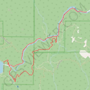
Name: Button Rock Dam Loop trail, distance, elevation, map, profile, GPS track
Start: Longmont Dam Road, Boulder County, Colorado, United States (40.22848 -105.34247)
End: Longmont Dam Road, Boulder County, Colorado, United States (40.22847 -105.34246)
Coordinates: 40.21252 -105.36735 40.22932 -105.34246
Topography: Boulder County topographic map, elevation, terrain
Thank you for supporting this site ❤️
Make a donation
Make a donation
Gear up for your next adventure:
As an Amazon Associate, this site earns from qualifying purchases at no extra cost to you.