Make a donation
Gear up for your next adventure:
As an Amazon Associate, this site earns from qualifying purchases at no extra cost to you.
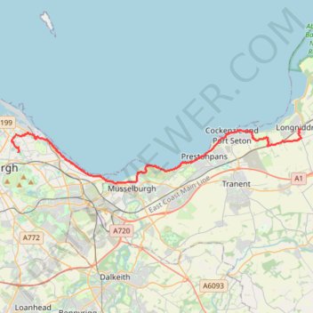
Ride from Longniddry to Edinburgh via Port Seton, Cockenzie, Prestonpans, Levenhall Links, Fisherrow, Joppa and Portobello
- Distance: 15.0 mi
- Elevation gain: 479 ft
- Maximum elevation: 151 ft
- Elevation loss: 472 ft
- Minimum elevation: 0 ft
- Moving time: 1 h 50 m
- Moving speed: 8.1 mph
- Maximum speed: 19.2 mph
- Total time: 2 h 7 m
- Global speed: 7.1 mph
Interactive trail map
Make a donation
Gear up for your next adventure:
As an Amazon Associate, this site earns from qualifying purchases at no extra cost to you.
Trail profile
- Distance: 15.0 mi
- Elevation gain: 479 ft
- Maximum elevation: 151 ft
- Elevation loss: 472 ft
- Minimum elevation: 0 ft
- Moving time: 1 h 50 m
- Moving speed: 8.1 mph
- Maximum speed: 19.2 mph
- Total time: 2 h 7 m
- Global speed: 7.1 mph
Make a donation
Gear up for your next adventure:
As an Amazon Associate, this site earns from qualifying purchases at no extra cost to you.
About this trail
Name: Ride from Longniddry to Edinburgh via Port Seton, Cockenzie, Prestonpans, Levenhall Links, Fisherrow, Joppa and Portobello trail, distance, elevation, map, profile, GPS track
Coordinates: 55.94445 -3.16928 55.97357 -2.89118
Make a donation
Gear up for your next adventure:
As an Amazon Associate, this site earns from qualifying purchases at no extra cost to you.
Other hiking, mountain biking, running and outdoor activity trails
Click on a trail to view its statistics, map and profile.
Edinburgh - Leith
United Kingdom > Scotland > City of Edinburgh
Distance: 7.8 mi • Elevation gain: 459 ft • Maximum elevation: 194 ft