Make a donation
Gear up for your next adventure:
As an Amazon Associate, this site earns from qualifying purchases at no extra cost to you.
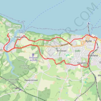
Ryde loop - Isle of Wight
- Distance: 10.2 mi
- Elevation gain: 778 ft
- Maximum elevation: 174 ft
- Elevation loss: 778 ft
- Minimum elevation: 0 ft
- Moving time: 1 h 35 m
- Moving speed: 6.4 mph
- Maximum speed: 9.1 mph
- Total time: 1 h 35 m
- Global speed: 6.4 mph
Interactive trail map
Make a donation
Gear up for your next adventure:
As an Amazon Associate, this site earns from qualifying purchases at no extra cost to you.
Trail profile
- Distance: 10.2 mi
- Elevation gain: 778 ft
- Maximum elevation: 174 ft
- Elevation loss: 778 ft
- Minimum elevation: 0 ft
- Moving time: 1 h 35 m
- Moving speed: 6.4 mph
- Maximum speed: 9.1 mph
- Total time: 1 h 35 m
- Global speed: 6.4 mph
Make a donation
Gear up for your next adventure:
As an Amazon Associate, this site earns from qualifying purchases at no extra cost to you.
About this trail
Name: Ryde loop - Isle of Wight trail, distance, elevation, map, profile, GPS track
Start: New Road, Wootton Bridge, Isle of Wight, England, PO33 4JP, United Kingdom (50.73361 -1.22406)
End: New Road, Wootton Bridge, Isle of Wight, England, PO33 4JP, United Kingdom (50.73357 -1.22409)
Coordinates: 50.71659 -1.22806 50.73364 -1.15346
Make a donation
Gear up for your next adventure:
As an Amazon Associate, this site earns from qualifying purchases at no extra cost to you.
Other hiking, mountain biking, running and outdoor activity trails
Click on a trail to view its statistics, map and profile.
Hovertravel Ryde to Southsea
United Kingdom > England > Isle of Wight > Ryde
Distance: 4.6 mi • Elevation gain: 7 ft • Maximum elevation: 7 ft