Thank you for supporting this site ❤️
Make a donation
Make a donation
Gear up for your next adventure:
As an Amazon Associate, this site earns from qualifying purchases at no extra cost to you.
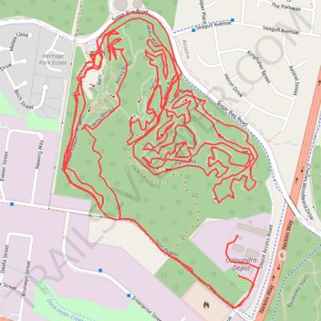
Sugar Bag Road Town Reserve Mountain Biking
Most of the trails #MTB
- Distance: 9.4 mi
- Elevation gain: 758 ft
- Maximum elevation: 177 ft
- Elevation loss: 758 ft
- Minimum elevation: 30 ft
- Moving time: 1 h 36 m
- Moving speed: 5.8 mph
- Maximum speed: 19.8 mph
- Total time: 2 h 43 m
- Global speed: 3.4 mph
Interactive trail map
Thank you for supporting this site ❤️
Make a donation
Make a donation
Gear up for your next adventure:
As an Amazon Associate, this site earns from qualifying purchases at no extra cost to you.
Trail profile
- Distance: 9.4 mi
- Elevation gain: 758 ft
- Maximum elevation: 177 ft
- Elevation loss: 758 ft
- Minimum elevation: 30 ft
- Moving time: 1 h 36 m
- Moving speed: 5.8 mph
- Maximum speed: 19.8 mph
- Total time: 2 h 43 m
- Global speed: 3.4 mph
Thank you for supporting this site ❤️
Make a donation
Make a donation
Gear up for your next adventure:
As an Amazon Associate, this site earns from qualifying purchases at no extra cost to you.
About this trail
Name: Sugar Bag Road Town Reserve Mountain Biking trail, distance, elevation, map, profile, GPS track
Coordinates: -26.79570 153.11245 -26.78549 153.12002
Thank you for supporting this site ❤️
Make a donation
Make a donation
Gear up for your next adventure:
As an Amazon Associate, this site earns from qualifying purchases at no extra cost to you.
Other hiking, mountain biking, running and outdoor activity trails
Click on a trail to view its statistics, map and profile.
Currimundi - Ewen Maddock Dam - Beerburrum
Australia > Queensland > Sunshine Coast Regional
Distance: 34.1 mi • Elevation gain: 1,460 ft • Maximum elevation: 154 ft