Thank you for supporting this site ❤️
Make a donation
Make a donation
Gear up for your next adventure:
As an Amazon Associate, this site earns from qualifying purchases at no extra cost to you.
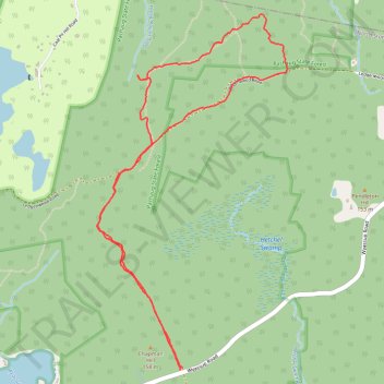
Loop hike in Pachaug State Forest from Wyassup Road via Ledgenwood Road
- Distance: 4.3 mi
- Elevation gain: 381 ft
- Maximum elevation: 518 ft
- Elevation loss: 377 ft
- Minimum elevation: 384 ft
- Moving time: 1 h 56 m
- Moving speed: 2.2 mph
- Maximum speed: 3.8 mph
- Total time: 2 h 20 m
- Global speed: 1.8 mph
Interactive trail map
Thank you for supporting this site ❤️
Make a donation
Make a donation
Gear up for your next adventure:
As an Amazon Associate, this site earns from qualifying purchases at no extra cost to you.
Trail profile
- Distance: 4.3 mi
- Elevation gain: 381 ft
- Maximum elevation: 518 ft
- Elevation loss: 377 ft
- Minimum elevation: 384 ft
- Moving time: 1 h 56 m
- Moving speed: 2.2 mph
- Maximum speed: 3.8 mph
- Total time: 2 h 20 m
- Global speed: 1.8 mph
Thank you for supporting this site ❤️
Make a donation
Make a donation
Gear up for your next adventure:
As an Amazon Associate, this site earns from qualifying purchases at no extra cost to you.
About this trail
Name: Loop hike in Pachaug State Forest from Wyassup Road via Ledgenwood Road trail, distance, elevation, map, profile, GPS track
Coordinates: 41.49238 -71.86534 41.51306 -71.85049
Topography: Southeastern Connecticut Planning Region topographic map, elevation, terrain
Thank you for supporting this site ❤️
Make a donation
Make a donation
Gear up for your next adventure:
As an Amazon Associate, this site earns from qualifying purchases at no extra cost to you.