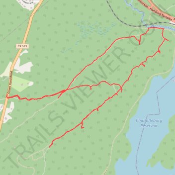
Loop hike via Four Birds Trail above Charlotteburg Reservoir - Newark Watershed
- Distance: 6.0 mi
- Elevation gain: 853 ft
- Maximum elevation: 1,165 ft
- Elevation loss: 853 ft
- Minimum elevation: 764 ft
- Moving time: 3 h 53 m
- Moving speed: 1.5 mph
- Maximum speed: 4.1 mph
- Total time: 5 h 45 m
- Global speed: 1.0 mph
Interactive trail map
Trail profile
- Distance: 6.0 mi
- Elevation gain: 853 ft
- Maximum elevation: 1,165 ft
- Elevation loss: 853 ft
- Minimum elevation: 764 ft
- Moving time: 3 h 53 m
- Moving speed: 1.5 mph
- Maximum speed: 4.1 mph
- Total time: 5 h 45 m
- Global speed: 1.0 mph
About this trail
Name: Loop hike via Four Birds Trail above Charlotteburg Reservoir - Newark Watershed trail, distance, elevation, map, profile, GPS track
Coordinates: 41.02395 -74.45412 41.03777 -74.42940
Topography: Morris County topographic map, elevation, terrain