Make a donation
Gear up for your next adventure:
As an Amazon Associate, this site earns from qualifying purchases at no extra cost to you.
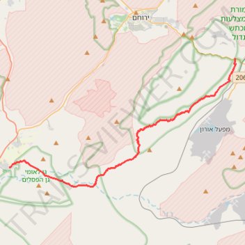
Yeruham Crater to Midreshet Ben Gurion
מכתש ירוחם למדרשת בן גוריון: מכתש גדול וטעימה ממדבר צין
- Distance: 21.3 mi
- Elevation gain: 4,301 ft
- Maximum elevation: 2,228 ft
- Elevation loss: 3,711 ft
- Minimum elevation: 873 ft
- Moving time: 10 h 12 m
- Moving speed: 2.1 mph
- Maximum speed: 2.6 mph
- Total time: 10 h 12 m
- Global speed: 2.1 mph
Interactive trail map
Make a donation
Gear up for your next adventure:
As an Amazon Associate, this site earns from qualifying purchases at no extra cost to you.
Trail profile
- Distance: 21.3 mi
- Elevation gain: 4,301 ft
- Maximum elevation: 2,228 ft
- Elevation loss: 3,711 ft
- Minimum elevation: 873 ft
- Moving time: 10 h 12 m
- Moving speed: 2.1 mph
- Maximum speed: 2.6 mph
- Total time: 10 h 12 m
- Global speed: 2.1 mph
Make a donation
Gear up for your next adventure:
As an Amazon Associate, this site earns from qualifying purchases at no extra cost to you.
About this trail
Name: Yeruham Crater to Midreshet Ben Gurion trail, distance, elevation, map, profile, GPS track
Coordinates: 30.83407 34.78503 30.95165 35.02653
Make a donation
Gear up for your next adventure:
As an Amazon Associate, this site earns from qualifying purchases at no extra cost to you.
Other hiking, mountain biking, running and outdoor activity trails
Click on a trail to view its statistics, map and profile.
Nahal Shualim to Midreshet Ben-Gurion
Israel > South District > Yeruham
נחל שועלים ורכס חתירה: קו גדול מירוחם למדרשת בן גוריון דרך נחל דרוך
Distance: 23.7 mi • Elevation gain: 2,756 ft • Maximum elevation: 2,254 ft
חיתוך בתוך המכתש הגדול, מנחל חתירה לסנפיר
Israel > South District > Ramat Negev Regional Council
Distance: 20.6 mi • Elevation gain: 3,625 ft • Maximum elevation: 2,234 ft
Mashashit and Tzayad Hike
Israel > South District > Ramat Negev Regional Council
ממשית והר צייד: דרך שרידי עיר נבטית ושמורת מצלעות המכתש הגדול
Distance: 20.1 mi • Elevation gain: 2,543 ft • Maximum elevation: 2,146 ft
Make a donation
Gear up for your next adventure:
As an Amazon Associate, this site earns from qualifying purchases at no extra cost to you.
Yeruham Crater - Karbolet
Israel > South District > Ramat Negev Regional Council
מכתש ירוחם והר כרבולת: מעגלי קטן בתוך המכתש הגדול
Distance: 11.8 mi • Elevation gain: 2,129 ft • Maximum elevation: 1,873 ft
Yeruham Crater Circle
Israel > South District > Ramat Negev Regional Council
סובב מכתש ירוחם: קו פנורמי, אלגנטי וגדול סביב תופעת טבע עוצרת נשימה
Distance: 25.1 mi • Elevation gain: 5,203 ft • Maximum elevation: 2,254 ft
Hod Ekev and Mount Tzror
Israel > South District > Ramat Negev Regional Council > Midreshet Ben-Gurion
חוד עקב והר צרור: מעלה דבשון, עין עקב וגב צרור
Distance: 13.6 mi • Elevation gain: 2,320 ft • Maximum elevation: 1,824 ft
קישור בין נחל דרוך לנחל תלול
Israel > South District > Ramat Negev Regional Council > Midreshet Ben-Gurion
Distance: 20.1 mi • Elevation gain: 2,205 ft • Maximum elevation: 2,057 ft
Make a donation
Gear up for your next adventure:
As an Amazon Associate, this site earns from qualifying purchases at no extra cost to you.
קישור בין נחל זקוף לנחל דרוך
Israel > South District > Ramat Negev Regional Council > Merchav Am
Distance: 23.6 mi • Elevation gain: 2,753 ft • Maximum elevation: 2,215 ft
עין ושרף פוביצר
Israel > South District > Arava Tichona Regional Council
Distance: 22.7 mi • Elevation gain: 3,071 ft • Maximum elevation: 1,545 ft