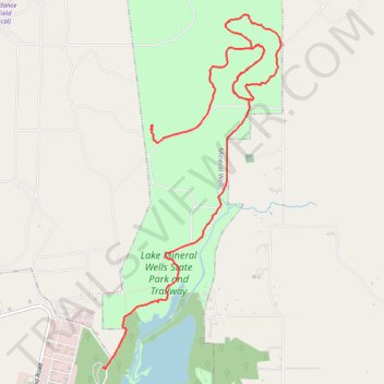
Lake Mineral Wells State Park Hike
- Distance: 7.5 mi
- Elevation gain: 374 ft
- Maximum elevation: 1,014 ft
- Elevation loss: 325 ft
- Minimum elevation: 879 ft
- Moving time: 2 h 32 m
- Moving speed: 2.9 mph
- Maximum speed: 3.9 mph
- Total time: 2 h 40 m
- Global speed: 2.8 mph
Interactive trail map
Trail profile
- Distance: 7.5 mi
- Elevation gain: 374 ft
- Maximum elevation: 1,014 ft
- Elevation loss: 325 ft
- Minimum elevation: 879 ft
- Moving time: 2 h 32 m
- Moving speed: 2.9 mph
- Maximum speed: 3.9 mph
- Total time: 2 h 40 m
- Global speed: 2.8 mph
About this trail
Name: Lake Mineral Wells State Park Hike trail, distance, elevation, map, profile, GPS track
Start: Parker County, Texas, United States (32.85986 -98.03080)
Coordinates: 32.83381 -98.03693 32.87235 -98.01391
Topography: Parker County topographic map, elevation, terrain