Thank you for supporting this site ❤️
Make a donation
Make a donation
Gear up for your next adventure:
As an Amazon Associate, this site earns from qualifying purchases at no extra cost to you.
Barak, Kippa and Vardit
ברק, ורדית וכיפה: שני קניונים משוגעים ותצפית על עמק עשוש בעומק הערבה
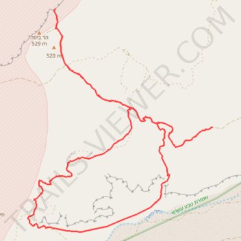
- Distance: 18.9 mi
- Elevation gain: 2,612 ft
- Maximum elevation: 1,670 ft
- Elevation loss: 2,612 ft
- Minimum elevation: 525 ft
- Moving time: 8 h 26 m
- Moving speed: 2.2 mph
- Maximum speed: 2.6 mph
- Total time: 8 h 26 m
- Global speed: 2.2 mph
Interactive trail map
Thank you for supporting this site ❤️
Make a donation
Make a donation
Gear up for your next adventure:
As an Amazon Associate, this site earns from qualifying purchases at no extra cost to you.
Trail profile
- Distance: 18.9 mi
- Elevation gain: 2,612 ft
- Maximum elevation: 1,670 ft
- Elevation loss: 2,612 ft
- Minimum elevation: 525 ft
- Moving time: 8 h 26 m
- Moving speed: 2.2 mph
- Maximum speed: 2.6 mph
- Total time: 8 h 26 m
- Global speed: 2.2 mph
Thank you for supporting this site ❤️
Make a donation
Make a donation
Gear up for your next adventure:
As an Amazon Associate, this site earns from qualifying purchases at no extra cost to you.
About this trail
Name: Barak, Kippa and Vardit trail, distance, elevation, map, profile, GPS track
Coordinates: 30.34684 35.02095 30.40993 35.08145
Thank you for supporting this site ❤️
Make a donation
Make a donation
Gear up for your next adventure:
As an Amazon Associate, this site earns from qualifying purchases at no extra cost to you.