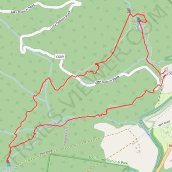
Three Falls Track - Mount Field National Park
- Distance: 4.1 mi
- Elevation gain: 705 ft
- Maximum elevation: 876 ft
- Elevation loss: 705 ft
- Minimum elevation: 568 ft
- Moving time: 2 h 17 m
- Moving speed: 1.8 mph
- Maximum speed: 4.6 mph
- Total time: 2 h 53 m
- Global speed: 1.4 mph
Interactive trail map
Trail profile
- Distance: 4.1 mi
- Elevation gain: 705 ft
- Maximum elevation: 876 ft
- Elevation loss: 705 ft
- Minimum elevation: 568 ft
- Moving time: 2 h 17 m
- Moving speed: 1.8 mph
- Maximum speed: 4.6 mph
- Total time: 2 h 53 m
- Global speed: 1.4 mph
About this trail
Name: Three Falls Track - Mount Field National Park trail, distance, elevation, map, profile, GPS track
Coordinates: -42.69082 146.69515 -42.67612 146.71619
Other hiking, mountain biking, running and outdoor activity trails
Click on a trail to view its statistics, map and profile.
Lady Barron Falls Track
Mount Field National Park. #Hiking #Loop #MountField #Tasmania
Distance: 4.3 mi • Elevation gain: 712 ft • Maximum elevation: 876 ft