Thank you for supporting this site ❤️
Make a donation
Make a donation
Gear up for your next adventure:
As an Amazon Associate, this site earns from qualifying purchases at no extra cost to you.
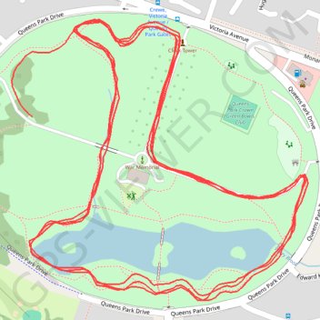
Crewe Parkrun
- Distance: 3.2 mi
- Elevation gain: 151 ft
- Maximum elevation: 177 ft
- Elevation loss: 135 ft
- Minimum elevation: 135 ft
- Moving time: 30 m 56 s
- Moving speed: 6.2 mph
- Maximum speed: 10.5 mph
- Total time: 30 m 56 s
- Global speed: 6.2 mph
Interactive trail map
Thank you for supporting this site ❤️
Make a donation
Make a donation
Gear up for your next adventure:
As an Amazon Associate, this site earns from qualifying purchases at no extra cost to you.
Trail profile
- Distance: 3.2 mi
- Elevation gain: 151 ft
- Maximum elevation: 177 ft
- Elevation loss: 135 ft
- Minimum elevation: 135 ft
- Moving time: 30 m 56 s
- Moving speed: 6.2 mph
- Maximum speed: 10.5 mph
- Total time: 30 m 56 s
- Global speed: 6.2 mph
Thank you for supporting this site ❤️
Make a donation
Make a donation
Gear up for your next adventure:
As an Amazon Associate, this site earns from qualifying purchases at no extra cost to you.
About this trail
Name: Crewe Parkrun trail, distance, elevation, map, profile, GPS track
Coordinates: 53.09521 -2.47116 53.09871 -2.46502
Thank you for supporting this site ❤️
Make a donation
Make a donation
Gear up for your next adventure:
As an Amazon Associate, this site earns from qualifying purchases at no extra cost to you.