Thank you for supporting this site ❤️
Make a donation
Make a donation
Gear up for your next adventure:
As an Amazon Associate, this site earns from qualifying purchases at no extra cost to you.
Heritage Ranch Loop
Red Deer River. #Hiking #Snowshoeing #Running #Loop
- Distance: 2.8 mi
- Elevation gain: 197 ft
- Maximum elevation: 2,907 ft
- Elevation loss: 200 ft
- Minimum elevation: 2,812 ft
Interactive trail map
Thank you for supporting this site ❤️
Make a donation
Make a donation
Gear up for your next adventure:
As an Amazon Associate, this site earns from qualifying purchases at no extra cost to you.
Trail profile
- Distance: 2.8 mi
- Elevation gain: 197 ft
- Maximum elevation: 2,907 ft
- Elevation loss: 200 ft
- Minimum elevation: 2,812 ft
Thank you for supporting this site ❤️
Make a donation
Make a donation
Gear up for your next adventure:
As an Amazon Associate, this site earns from qualifying purchases at no extra cost to you.
About this trail
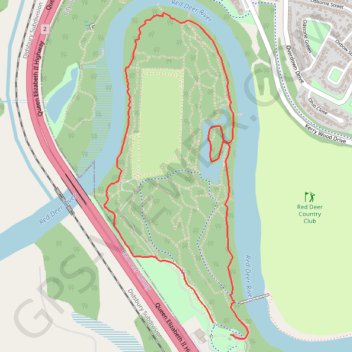
Name: Heritage Ranch Loop trail, distance, elevation, map, profile, GPS track
Start: Heritage Ranch Trail, Red Deer, Alberta, T4N 1E3, Canada (52.26254 -113.85312)
End: Heritage Ranch Trail, Red Deer, Alberta, T4N 1E3, Canada (52.26201 -113.85190)
Coordinates: 52.26184 -113.86105 52.27627 -113.85061
Thank you for supporting this site ❤️
Make a donation
Make a donation
Gear up for your next adventure:
As an Amazon Associate, this site earns from qualifying purchases at no extra cost to you.