Thank you for supporting this site ❤️
Make a donation
Make a donation
Gear up for your next adventure:
As an Amazon Associate, this site earns from qualifying purchases at no extra cost to you.
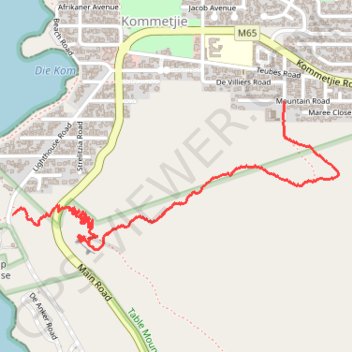
Kommetjie
- Distance: 1.8 mi
- Elevation gain: 561 ft
- Maximum elevation: 495 ft
- Elevation loss: 489 ft
- Minimum elevation: 30 ft
- Moving time: 1 h 14 m
- Moving speed: 1.5 mph
- Maximum speed: 24.4 mph
- Total time: 1 h 42 m
- Global speed: 1.1 mph
Interactive trail map
Thank you for supporting this site ❤️
Make a donation
Make a donation
Gear up for your next adventure:
As an Amazon Associate, this site earns from qualifying purchases at no extra cost to you.
Trail profile
- Distance: 1.8 mi
- Elevation gain: 561 ft
- Maximum elevation: 495 ft
- Elevation loss: 489 ft
- Minimum elevation: 30 ft
- Moving time: 1 h 14 m
- Moving speed: 1.5 mph
- Maximum speed: 24.4 mph
- Total time: 1 h 42 m
- Global speed: 1.1 mph
Thank you for supporting this site ❤️
Make a donation
Make a donation
Gear up for your next adventure:
As an Amazon Associate, this site earns from qualifying purchases at no extra cost to you.
About this trail
Name: Kommetjie trail, distance, elevation, map, profile, GPS track
Coordinates: -34.14862 18.32054 -34.14300 18.33547
Thank you for supporting this site ❤️
Make a donation
Make a donation
Gear up for your next adventure:
As an Amazon Associate, this site earns from qualifying purchases at no extra cost to you.