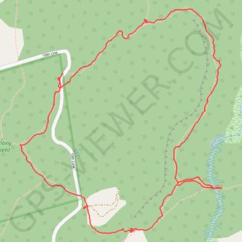
Kolapore trail loop
- Distance: 2.4 mi
- Elevation gain: 285 ft
- Maximum elevation: 1,542 ft
- Elevation loss: 285 ft
- Minimum elevation: 1,362 ft
- Moving time: 57 m 15 s
- Moving speed: 2.5 mph
- Maximum speed: 5.2 mph
- Total time: 1 h 1 m
- Global speed: 2.3 mph
Interactive trail map
Trail profile
- Distance: 2.4 mi
- Elevation gain: 285 ft
- Maximum elevation: 1,542 ft
- Elevation loss: 285 ft
- Minimum elevation: 1,362 ft
- Moving time: 57 m 15 s
- Moving speed: 2.5 mph
- Maximum speed: 5.2 mph
- Total time: 1 h 1 m
- Global speed: 2.3 mph
About this trail
Name: Kolapore trail loop trail, distance, elevation, map, profile, GPS track
Start: 10th Line, The Blue Mountains, Grey County, Ontario, Canada (44.41177 -80.43853)
End: 10th Line, The Blue Mountains, Grey County, Ontario, Canada (44.41173 -80.43860)
Coordinates: 44.40579 -80.44069 44.41449 -80.42970
Other hiking, mountain biking, running and outdoor activity trails
Click on a trail to view its statistics, map and profile.
Owen Sound - Orangeville
Canada > Ontario > Grey County > Owen Sound
Distance: 66.9 mi • Elevation gain: 1,946 ft • Maximum elevation: 1,696 ft