Thank you for supporting this site ❤️
Make a donation
Make a donation
Gear up for your next adventure:
As an Amazon Associate, this site earns from qualifying purchases at no extra cost to you.
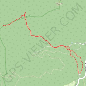
Mount Charleston Wilderness
- Distance: 4.8 mi
- Elevation gain: 1,378 ft
- Maximum elevation: 9,593 ft
- Elevation loss: 1,385 ft
- Minimum elevation: 8,383 ft
- Moving time: 2 h 7 m
- Moving speed: 2.2 mph
- Maximum speed: 4.1 mph
- Total time: 2 h 17 m
- Global speed: 2.1 mph
Interactive trail map
Thank you for supporting this site ❤️
Make a donation
Make a donation
Gear up for your next adventure:
As an Amazon Associate, this site earns from qualifying purchases at no extra cost to you.
Trail profile
- Distance: 4.8 mi
- Elevation gain: 1,378 ft
- Maximum elevation: 9,593 ft
- Elevation loss: 1,385 ft
- Minimum elevation: 8,383 ft
- Moving time: 2 h 7 m
- Moving speed: 2.2 mph
- Maximum speed: 4.1 mph
- Total time: 2 h 17 m
- Global speed: 2.1 mph
Thank you for supporting this site ❤️
Make a donation
Make a donation
Gear up for your next adventure:
As an Amazon Associate, this site earns from qualifying purchases at no extra cost to you.
About this trail
Name: Mount Charleston Wilderness trail, distance, elevation, map, profile, GPS track
Start: Lower Bristlecone Trail, Clark County, Nevada, United States (36.31213 -115.67731)
End: Lower Bristlecone Trail, Clark County, Nevada, United States (36.31222 -115.67705)
Coordinates: 36.31213 -115.70210 36.32841 -115.67618
Topography: Clark County topographic map, elevation, terrain
Thank you for supporting this site ❤️
Make a donation
Make a donation
Gear up for your next adventure:
As an Amazon Associate, this site earns from qualifying purchases at no extra cost to you.