Make a donation
Gear up for your next adventure:
As an Amazon Associate, this site earns from qualifying purchases at no extra cost to you.
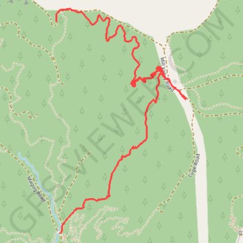
Rimrock lower&upper Eskdale MTB
- Distance: 2.3 mi
- Elevation gain: 413 ft
- Maximum elevation: 840 ft
- Elevation loss: 1,125 ft
- Minimum elevation: 98 ft
- Moving time: 26 m 35 s
- Moving speed: 5.2 mph
- Maximum speed: 19.1 mph
- Total time: 32 m 8 s
- Global speed: 4.3 mph
Interactive trail map
Make a donation
Gear up for your next adventure:
As an Amazon Associate, this site earns from qualifying purchases at no extra cost to you.
Trail profile
- Distance: 2.3 mi
- Elevation gain: 413 ft
- Maximum elevation: 840 ft
- Elevation loss: 1,125 ft
- Minimum elevation: 98 ft
- Moving time: 26 m 35 s
- Moving speed: 5.2 mph
- Maximum speed: 19.1 mph
- Total time: 32 m 8 s
- Global speed: 4.3 mph
Make a donation
Gear up for your next adventure:
As an Amazon Associate, this site earns from qualifying purchases at no extra cost to you.
About this trail
Name: Rimrock lower&upper Eskdale MTB trail, distance, elevation, map, profile, GPS track
Start: Ridgeline Road, Hastings District, Hawke's Bay, 4182, New Zealand (-39.37356 176.83623)
End: T-Bar, Eskdale, Hastings District, Hawke's Bay, 4182, New Zealand (-39.38485 176.83653)
Coordinates: -39.38485 176.83621 -39.37290 176.84514
Make a donation
Gear up for your next adventure:
As an Amazon Associate, this site earns from qualifying purchases at no extra cost to you.
Other hiking, mountain biking, running and outdoor activity trails
Click on a trail to view its statistics, map and profile.
Eskdale MTB Trails
New Zealand > Hawke's Bay > Hastings District
Distance: 12.8 mi • Elevation gain: 2,034 ft • Maximum elevation: 781 ft
Eskdale MTB
New Zealand > Hawke's Bay > Hastings District
Distance: 12.5 mi • Elevation gain: 2,146 ft • Maximum elevation: 817 ft
Eskdale MTB
New Zealand > Hawke's Bay > Hastings District
Distance: 11.9 mi • Elevation gain: 2,172 ft • Maximum elevation: 906 ft
Eskdale
New Zealand > Hawke's Bay > Hastings District
Distance: 12.4 mi • Elevation gain: 2,008 ft • Maximum elevation: 784 ft
Make a donation
Gear up for your next adventure:
As an Amazon Associate, this site earns from qualifying purchases at no extra cost to you.