Thank you for supporting this site ❤️
Make a donation
Make a donation
Gear up for your next adventure:
As an Amazon Associate, this site earns from qualifying purchases at no extra cost to you.
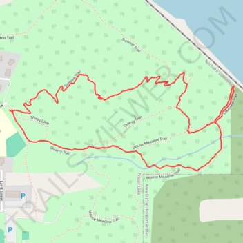
Mouse Mountain Park : summit, lakeview, meadow and quarry trails loop
- Distance: 1.7 mi
- Elevation gain: 449 ft
- Maximum elevation: 2,648 ft
- Elevation loss: 453 ft
- Minimum elevation: 2,224 ft
- Moving time: 52 m 38 s
- Moving speed: 1.9 mph
- Maximum speed: 5.5 mph
- Total time: 1 h 23 m
- Global speed: 1.2 mph
Interactive trail map
Thank you for supporting this site ❤️
Make a donation
Make a donation
Gear up for your next adventure:
As an Amazon Associate, this site earns from qualifying purchases at no extra cost to you.
Trail profile
- Distance: 1.7 mi
- Elevation gain: 449 ft
- Maximum elevation: 2,648 ft
- Elevation loss: 453 ft
- Minimum elevation: 2,224 ft
- Moving time: 52 m 38 s
- Moving speed: 1.9 mph
- Maximum speed: 5.5 mph
- Total time: 1 h 23 m
- Global speed: 1.2 mph
Thank you for supporting this site ❤️
Make a donation
Make a donation
Gear up for your next adventure:
As an Amazon Associate, this site earns from qualifying purchases at no extra cost to you.
About this trail
Name: Mouse Mountain Park : summit, lakeview, meadow and quarry trails loop trail, distance, elevation, map, profile, GPS track
Coordinates: 54.05906 -124.83675 54.06203 -124.82517
Thank you for supporting this site ❤️
Make a donation
Make a donation
Gear up for your next adventure:
As an Amazon Associate, this site earns from qualifying purchases at no extra cost to you.