Thank you for supporting this site ❤️
Make a donation
Make a donation
Gear up for your next adventure:
As an Amazon Associate, this site earns from qualifying purchases at no extra cost to you.
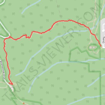
Laurieton walking track
- Distance: 1.7 mi
- Elevation gain: 1,407 ft
- Maximum elevation: 1,539 ft
- Elevation loss: 33 ft
- Minimum elevation: 151 ft
- Moving time: 48 m 59 s
- Moving speed: 2.1 mph
- Maximum speed: 4.9 mph
- Total time: 55 m 6 s
- Global speed: 1.8 mph
Interactive trail map
Thank you for supporting this site ❤️
Make a donation
Make a donation
Gear up for your next adventure:
As an Amazon Associate, this site earns from qualifying purchases at no extra cost to you.
Trail profile
- Distance: 1.7 mi
- Elevation gain: 1,407 ft
- Maximum elevation: 1,539 ft
- Elevation loss: 33 ft
- Minimum elevation: 151 ft
- Moving time: 48 m 59 s
- Moving speed: 2.1 mph
- Maximum speed: 4.9 mph
- Total time: 55 m 6 s
- Global speed: 1.8 mph
Thank you for supporting this site ❤️
Make a donation
Make a donation
Gear up for your next adventure:
As an Amazon Associate, this site earns from qualifying purchases at no extra cost to you.
About this trail
Name: Laurieton walking track trail, distance, elevation, map, profile, GPS track
Start: Laurieton Walking Track, Laurieton, New South Wales, 2443, Australia (-31.65218 152.79137)
End: Rainforest Loop Track, New South Wales, 2443, Australia (-31.65691 152.77734)
Coordinates: -31.65713 152.77660 -31.64880 152.79137
Thank you for supporting this site ❤️
Make a donation
Make a donation
Gear up for your next adventure:
As an Amazon Associate, this site earns from qualifying purchases at no extra cost to you.