Import a GPX file

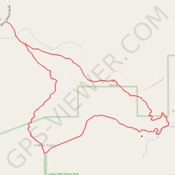
Pushawalla Palms and Hidden Palms Loop

Loop hike to Pushawalla Palms and Hidden Palms in the Coachella Valley Preserve. #Hiking #Loop #Nature #Desert

  • Distance: 4.9 mi
  • Elevation gain: 725 ft
  • Maximum elevation: 827 ft
  • Elevation loss: 725 ft
  • Minimum elevation: 371 ft

Interactive trail map

Trail profile

  • Distance: 4.9 mi
  • Elevation gain: 725 ft
  • Maximum elevation: 827 ft
  • Elevation loss: 725 ft
  • Minimum elevation: 371 ft

About this trail

Other hiking, mountain biking, running and outdoor activity trails

Click on a trail to view its statistics, map and profile.

Pushawalla Palms Loop

United States > California > Riverside County

Loop hike from Indian Palms Trailhead to Pushawalla Palms in the Indio Hills Palms Park. #Hiking #Loop #Nature #Desert #Forest #Park

Distance: 4.8 mi • Elevation gain: 741 ft • Maximum elevation: 823 ft

Gear up for your next adventure:

🦶Hiking Gaiters - Keep debris and water out of your boots
🎒Gear Packing Cubes - Organize your backpack efficiently
🥾Women's Hiking Boots - Top-rated trail boots with ankle support and superior grip
📶Vehicle Signal Boosters - Improve reception in rural areas while driving to trailheads
🚑Emergency Bivvies - Heat-reflective sleeping bags for survival situations

As an Amazon Associate, this site earns from qualifying purchases at no extra cost to you.