Make a donation
Gear up for your next adventure:
As an Amazon Associate, this site earns from qualifying purchases at no extra cost to you.
20260530072618 Hiking·Zepp Coach
- Distance: 1.9 mi
- Elevation gain: 262 ft
- Maximum elevation: 492 ft
- Elevation loss: 269 ft
- Minimum elevation: 295 ft
- Moving time: 1 h 3 m
- Moving speed: 1.8 mph
- Maximum speed: 4.5 mph
- Total time: 1 h 44 m
- Global speed: 1.1 mph
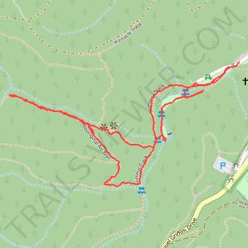
Interactive trail map
Make a donation
Gear up for your next adventure:
As an Amazon Associate, this site earns from qualifying purchases at no extra cost to you.
Trail profile
- Distance: 1.9 mi
- Elevation gain: 262 ft
- Maximum elevation: 492 ft
- Elevation loss: 269 ft
- Minimum elevation: 295 ft
- Moving time: 1 h 3 m
- Moving speed: 1.8 mph
- Maximum speed: 4.5 mph
- Total time: 1 h 44 m
- Global speed: 1.1 mph
Make a donation
Gear up for your next adventure:
As an Amazon Associate, this site earns from qualifying purchases at no extra cost to you.
About this trail
Name: 20260530072618 Hiking·Zepp Coach trail, distance, elevation, map, profile, GPS track
Start: Summit Track, Mount Coot-tha, Brisbane, Queensland, 4066, Australia (-27.47373 152.96644)
End: JC Slaughter Falls, Mount Coot-tha, Brisbane, Queensland, 4066, Australia (-27.47354 152.96682)
Coordinates: -27.47788 152.95784 -27.47354 152.96682
Make a donation
Gear up for your next adventure:
As an Amazon Associate, this site earns from qualifying purchases at no extra cost to you.
Other hiking, mountain biking, running and outdoor activity trails
Click on a trail to view its statistics, map and profile.
Make a donation
Gear up for your next adventure:
As an Amazon Associate, this site earns from qualifying purchases at no extra cost to you.
Mount Coot-Tha trails
Brisbane Trail Run
Distance: 14.5 mi • Elevation gain: 2,762 ft • Maximum elevation: 856 ft