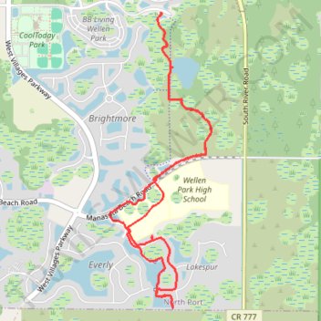
Oakheart Trail
- Distance: 6.4 mi
- Elevation gain: 49 ft
- Maximum elevation: 20 ft
- Elevation loss: 49 ft
- Minimum elevation: 7 ft
- Moving time: 54 m 21 s
- Moving speed: 7.1 mph
- Maximum speed: 13.1 mph
- Total time: 1 h 17 m
- Global speed: 5.0 mph
Interactive trail map
Trail profile
- Distance: 6.4 mi
- Elevation gain: 49 ft
- Maximum elevation: 20 ft
- Elevation loss: 49 ft
- Minimum elevation: 7 ft
- Moving time: 54 m 21 s
- Moving speed: 7.1 mph
- Maximum speed: 13.1 mph
- Total time: 1 h 17 m
- Global speed: 5.0 mph
About this trail
Name: Oakheart Trail trail, distance, elevation, map, profile, GPS track
Start: Playmore Road, North Port, Sarasota County, Florida, United States (27.03395 -82.30444)
End: Playmore Road, North Port, Sarasota County, Florida, United States (27.03407 -82.30451)
Coordinates: 27.00530 -82.31013 27.03413 -82.29900
Topography: Sarasota County topographic map, elevation, terrain