Make a donation
Gear up for your next adventure:
As an Amazon Associate, this site earns from qualifying purchases at no extra cost to you.
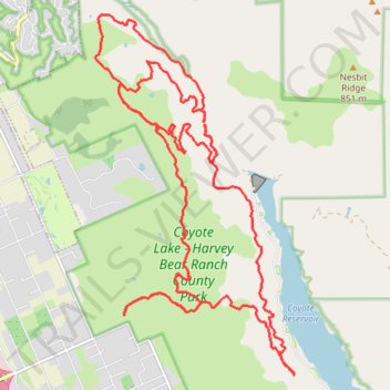
Coyote Lake - Harvey Bear Ranch County Park MTB Ride
- Distance: 18.7 mi
- Elevation gain: 2,877 ft
- Maximum elevation: 1,463 ft
- Elevation loss: 2,877 ft
- Minimum elevation: 354 ft
- Moving time: 2 h 39 m
- Moving speed: 7.0 mph
- Maximum speed: 32.0 mph
- Total time: 3 h 18 m
- Global speed: 5.6 mph
Interactive trail map
Make a donation
Gear up for your next adventure:
As an Amazon Associate, this site earns from qualifying purchases at no extra cost to you.
Trail profile
- Distance: 18.7 mi
- Elevation gain: 2,877 ft
- Maximum elevation: 1,463 ft
- Elevation loss: 2,877 ft
- Minimum elevation: 354 ft
- Moving time: 2 h 39 m
- Moving speed: 7.0 mph
- Maximum speed: 32.0 mph
- Total time: 3 h 18 m
- Global speed: 5.6 mph
Make a donation
Gear up for your next adventure:
As an Amazon Associate, this site earns from qualifying purchases at no extra cost to you.
About this trail
Name: Coyote Lake - Harvey Bear Ranch County Park MTB Ride trail, distance, elevation, map, profile, GPS track
Start: Martin Murphy Trail, Santa Clara County, California, 94046, United States (37.09861 -121.57568)
End: Martin Murphy Trail, Santa Clara County, California, 94046, United States (37.09853 -121.57565)
Coordinates: 37.08937 -121.58123 37.14412 -121.54328
Topography: Santa Clara County topographic map, elevation, terrain
Make a donation
Gear up for your next adventure:
As an Amazon Associate, this site earns from qualifying purchases at no extra cost to you.