Make a donation
Gear up for your next adventure:
As an Amazon Associate, this site earns from qualifying purchases at no extra cost to you.
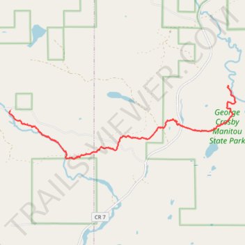
USA MN SHT - Sonju Lake Road Trailhead to Manitou State Park
- Distance: 5.3 mi
- Elevation gain: 459 ft
- Maximum elevation: 1,555 ft
- Elevation loss: 591 ft
- Minimum elevation: 1,322 ft
- Moving time: 2 h 45 m
- Moving speed: 1.9 mph
- Maximum speed: 3.2 mph
- Total time: 3 h 17 s
- Global speed: 1.8 mph
Interactive trail map
Make a donation
Gear up for your next adventure:
As an Amazon Associate, this site earns from qualifying purchases at no extra cost to you.
Trail profile
- Distance: 5.3 mi
- Elevation gain: 459 ft
- Maximum elevation: 1,555 ft
- Elevation loss: 591 ft
- Minimum elevation: 1,322 ft
- Moving time: 2 h 45 m
- Moving speed: 1.9 mph
- Maximum speed: 3.2 mph
- Total time: 3 h 17 s
- Global speed: 1.8 mph
Make a donation
Gear up for your next adventure:
As an Amazon Associate, this site earns from qualifying purchases at no extra cost to you.
About this trail
Name: USA MN SHT - Sonju Lake Road Trailhead to Manitou State Park trail, distance, elevation, map, profile, GPS track
Coordinates: 47.47219 -91.17872 47.48828 -91.10541
Topography: Crystal Bay Township topographic map, elevation, terrain
Make a donation
Gear up for your next adventure:
As an Amazon Associate, this site earns from qualifying purchases at no extra cost to you.
Other hiking, mountain biking, running and outdoor activity trails
Click on a trail to view its statistics, map and profile.
USA MN SHT - Manitou State Park to Crystal Creek Campsite
United States > Minnesota > Lake County > Lake No. 1
Distance: 8.2 mi • Elevation gain: 1,070 ft • Maximum elevation: 1,611 ft