Make a donation
Gear up for your next adventure:
As an Amazon Associate, this site earns from qualifying purchases at no extra cost to you.
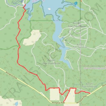
Wilman Bilya trail collie near Wellington dam south side
- Distance: 17.6 mi
- Elevation gain: 1,749 ft
- Maximum elevation: 974 ft
- Elevation loss: 1,752 ft
- Minimum elevation: 502 ft
- Moving time: 3 h 47 m
- Moving speed: 4.6 mph
- Maximum speed: 7.5 mph
- Total time: 3 h 50 m
- Global speed: 4.6 mph
Interactive trail map
Make a donation
Gear up for your next adventure:
As an Amazon Associate, this site earns from qualifying purchases at no extra cost to you.
Trail profile
- Distance: 17.6 mi
- Elevation gain: 1,749 ft
- Maximum elevation: 974 ft
- Elevation loss: 1,752 ft
- Minimum elevation: 502 ft
- Moving time: 3 h 47 m
- Moving speed: 4.6 mph
- Maximum speed: 7.5 mph
- Total time: 3 h 50 m
- Global speed: 4.6 mph
Make a donation
Gear up for your next adventure:
As an Amazon Associate, this site earns from qualifying purchases at no extra cost to you.
About this trail
Name: Wilman Bilya trail collie near Wellington dam south side trail, distance, elevation, map, profile, GPS track
Coordinates: -33.46570 115.97256 -33.40072 116.03132
Make a donation
Gear up for your next adventure:
As an Amazon Associate, this site earns from qualifying purchases at no extra cost to you.
Other hiking, mountain biking, running and outdoor activity trails
Click on a trail to view its statistics, map and profile.
Wilman Bilya trail collie near South east side
Australia > Western Australia > Mungalup
Distance: 13.7 mi • Elevation gain: 1,430 ft • Maximum elevation: 899 ft
Wiilman Bilya Trail Connell Road Area
Australia > Western Australia > Mungalup
Distance: 12.0 mi • Elevation gain: 1,476 ft • Maximum elevation: 860 ft