Thank you for supporting this site ❤️
Make a donation
Make a donation
Gear up for your next adventure:
As an Amazon Associate, this site earns from qualifying purchases at no extra cost to you.
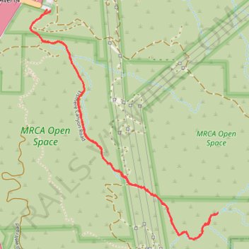
Elsmere Canyon Trail
- Distance: 2.9 mi
- Elevation gain: 318 ft
- Maximum elevation: 1,673 ft
- Elevation loss: 325 ft
- Minimum elevation: 1,444 ft
- Moving time: 1 h 8 m
- Moving speed: 2.6 mph
- Maximum speed: 16.0 mph
- Total time: 1 h 24 m
- Global speed: 2.1 mph
Interactive trail map
Thank you for supporting this site ❤️
Make a donation
Make a donation
Gear up for your next adventure:
As an Amazon Associate, this site earns from qualifying purchases at no extra cost to you.
Trail profile
- Distance: 2.9 mi
- Elevation gain: 318 ft
- Maximum elevation: 1,673 ft
- Elevation loss: 325 ft
- Minimum elevation: 1,444 ft
- Moving time: 1 h 8 m
- Moving speed: 2.6 mph
- Maximum speed: 16.0 mph
- Total time: 1 h 24 m
- Global speed: 2.1 mph
Thank you for supporting this site ❤️
Make a donation
Make a donation
Gear up for your next adventure:
As an Amazon Associate, this site earns from qualifying purchases at no extra cost to you.
About this trail
Name: Elsmere Canyon Trail trail, distance, elevation, map, profile, GPS track
Coordinates: 34.35155 -118.50213 34.36436 -118.48948
Topography: Santa Clarita topographic map, elevation, terrain
Thank you for supporting this site ❤️
Make a donation
Make a donation
Gear up for your next adventure:
As an Amazon Associate, this site earns from qualifying purchases at no extra cost to you.
Other hiking, mountain biking, running and outdoor activity trails
Click on a trail to view its statistics, map and profile.
The Beast - Whitney Canyon Park
United States > California > Los Angeles County > Santa Clarita
Distance: 5.2 mi • Elevation gain: 1,280 ft • Maximum elevation: 2,621 ft