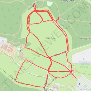
Westonbirt Downs
- Distance: 2.6 mi
- Elevation gain: 180 ft
- Maximum elevation: 479 ft
- Elevation loss: 174 ft
- Minimum elevation: 387 ft
- Moving time: 44 m 13 s
- Moving speed: 3.6 mph
- Maximum speed: 4.7 mph
- Total time: 50 m 55 s
- Global speed: 3.1 mph
Interactive trail map
Trail profile
- Distance: 2.6 mi
- Elevation gain: 180 ft
- Maximum elevation: 479 ft
- Elevation loss: 174 ft
- Minimum elevation: 387 ft
- Moving time: 44 m 13 s
- Moving speed: 3.6 mph
- Maximum speed: 4.7 mph
- Total time: 50 m 55 s
- Global speed: 3.1 mph
About this trail
Name: Westonbirt Downs trail, distance, elevation, map, profile, GPS track
Coordinates: 51.60527 -2.22057 51.61050 -2.21445
Other hiking, mountain biking, running and outdoor activity trails
Click on a trail to view its statistics, map and profile.
Westonbirt Arboretum
United Kingdom > England > Gloucestershire > Cotswold District > Westonbirt
Walk
Distance: 2.9 mi • Elevation gain: 108 ft • Maximum elevation: 479 ft
Westonbirt Old Arboretum tracks
United Kingdom > England > Gloucestershire > Cotswold District > Westonbirt
Distance: 6.5 mi • Elevation gain: 322 ft • Maximum elevation: 479 ft
Tetbury Westonbirt Loop
United Kingdom > England > Gloucestershire > Cotswold District > Tetbury
Distance: 16.3 mi • Elevation gain: 820 ft • Maximum elevation: 479 ft
Dean2023-311
United Kingdom > England > Oxfordshire > Oxford
Distance: 192.8 mi • Elevation gain: 11,043 ft • Maximum elevation: 951 ft