Make a donation
Gear up for your next adventure:
As an Amazon Associate, this site earns from qualifying purchases at no extra cost to you.
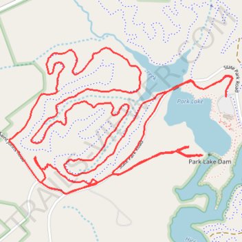
Lake Norman State Park Trail Run
- Distance: 6.6 mi
- Elevation gain: 466 ft
- Maximum elevation: 892 ft
- Elevation loss: 463 ft
- Minimum elevation: 778 ft
- Moving time: 1 h 23 m
- Moving speed: 4.7 mph
- Maximum speed: 10.8 mph
- Total time: 1 h 25 m
- Global speed: 4.6 mph
Interactive trail map
Make a donation
Gear up for your next adventure:
As an Amazon Associate, this site earns from qualifying purchases at no extra cost to you.
Trail profile
- Distance: 6.6 mi
- Elevation gain: 466 ft
- Maximum elevation: 892 ft
- Elevation loss: 463 ft
- Minimum elevation: 778 ft
- Moving time: 1 h 23 m
- Moving speed: 4.7 mph
- Maximum speed: 10.8 mph
- Total time: 1 h 25 m
- Global speed: 4.6 mph
Make a donation
Gear up for your next adventure:
As an Amazon Associate, this site earns from qualifying purchases at no extra cost to you.
About this trail
Name: Lake Norman State Park Trail Run trail, distance, elevation, map, profile, GPS track
Start: Alder Trail, Iredell County, North Carolina, United States (35.67362 -80.93268)
End: Alder Trail, Iredell County, North Carolina, United States (35.67377 -80.93268)
Coordinates: 35.66807 -80.94799 35.67645 -80.93219
Topography: Iredell County topographic map, elevation, terrain
Make a donation
Gear up for your next adventure:
As an Amazon Associate, this site earns from qualifying purchases at no extra cost to you.
Other hiking, mountain biking, running and outdoor activity trails
Click on a trail to view its statistics, map and profile.
Laurel Loop and Fallstown Loop in Lake Norman State Park
United States > North Carolina > Iredell County
Distance: 7.6 mi • Elevation gain: 397 ft • Maximum elevation: 869 ft
Lake Norman State Park
United States > North Carolina > Iredell County
Statesville Trail Run
Distance: 4.4 mi • Elevation gain: 276 ft • Maximum elevation: 869 ft
Lake Norman State Park
United States > North Carolina > Iredell County
Laurel Loop, Alder Trail and Hawk Loop
Distance: 7.8 mi • Elevation gain: 486 ft • Maximum elevation: 856 ft