Thank you for supporting this site ❤️
Make a donation
Make a donation
Gear up for your next adventure:
As an Amazon Associate, this site earns from qualifying purchases at no extra cost to you.
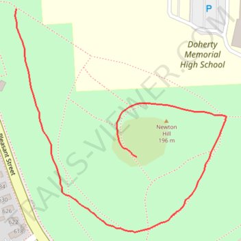
Newton Hill
- Distance: 0.6 mi
- Elevation gain: 26 ft
- Maximum elevation: 643 ft
- Elevation loss: 118 ft
- Minimum elevation: 545 ft
- Moving time: 15 m
- Moving speed: 2.3 mph
- Maximum speed: 3.2 mph
- Total time: 15 m
- Global speed: 2.3 mph
Interactive trail map
Thank you for supporting this site ❤️
Make a donation
Make a donation
Gear up for your next adventure:
As an Amazon Associate, this site earns from qualifying purchases at no extra cost to you.
Trail profile
- Distance: 0.6 mi
- Elevation gain: 26 ft
- Maximum elevation: 643 ft
- Elevation loss: 118 ft
- Minimum elevation: 545 ft
- Moving time: 15 m
- Moving speed: 2.3 mph
- Maximum speed: 3.2 mph
- Total time: 15 m
- Global speed: 2.3 mph
Thank you for supporting this site ❤️
Make a donation
Make a donation
Gear up for your next adventure:
As an Amazon Associate, this site earns from qualifying purchases at no extra cost to you.
About this trail
Name: Newton Hill trail, distance, elevation, map, profile, GPS track
Coordinates: 42.26603 -71.82377 42.26916 -71.81977
Topography: Worcester topographic map, elevation, terrain
Thank you for supporting this site ❤️
Make a donation
Make a donation
Gear up for your next adventure:
As an Amazon Associate, this site earns from qualifying purchases at no extra cost to you.
Other hiking, mountain biking, running and outdoor activity trails
Click on a trail to view its statistics, map and profile.
Loop in Eastern Mass involving various rail trails
United States > Massachusetts > Middlesex County > Newton
Distance: 126.6 mi • Elevation gain: 6,365 ft • Maximum elevation: 636 ft