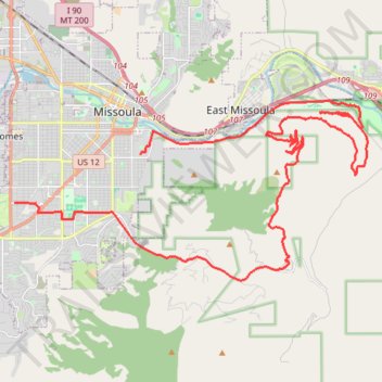
University Mountain Trail
- Distance: 24.6 mi
- Elevation gain: 3,533 ft
- Maximum elevation: 5,518 ft
- Elevation loss: 3,589 ft
- Minimum elevation: 3,169 ft
- Moving time: 2 h 46 m
- Moving speed: 8.9 mph
- Maximum speed: 32.2 mph
- Total time: 3 h 6 m
- Global speed: 7.9 mph
Interactive trail map
Trail profile
- Distance: 24.6 mi
- Elevation gain: 3,533 ft
- Maximum elevation: 5,518 ft
- Elevation loss: 3,589 ft
- Minimum elevation: 3,169 ft
- Moving time: 2 h 46 m
- Moving speed: 8.9 mph
- Maximum speed: 32.2 mph
- Total time: 3 h 6 m
- Global speed: 7.9 mph
About this trail
Name: University Mountain Trail trail, distance, elevation, map, profile, GPS track
End: 2435, Mary Avenue, Missoula, Missoula County, Montana, 59801, United States (46.84420 -114.03785)
Coordinates: 46.82211 -114.03785 46.87318 -113.89153
Topography: Missoula topographic map, elevation, terrain