Make a donation
Gear up for your next adventure:
As an Amazon Associate, this site earns from qualifying purchases at no extra cost to you.
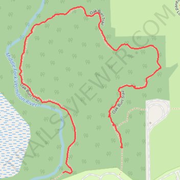
Oak Burl Trail in Middle Fork River Forest Preserve
- Distance: 1.3 mi
- Elevation gain: 33 ft
- Maximum elevation: 732 ft
- Elevation loss: 39 ft
- Minimum elevation: 702 ft
- Moving time: 1 h 1 m
- Moving speed: 1.3 mph
- Maximum speed: 2.8 mph
- Total time: 1 h 6 m
- Global speed: 1.2 mph
Interactive trail map
Make a donation
Gear up for your next adventure:
As an Amazon Associate, this site earns from qualifying purchases at no extra cost to you.
Trail profile
- Distance: 1.3 mi
- Elevation gain: 33 ft
- Maximum elevation: 732 ft
- Elevation loss: 39 ft
- Minimum elevation: 702 ft
- Moving time: 1 h 1 m
- Moving speed: 1.3 mph
- Maximum speed: 2.8 mph
- Total time: 1 h 6 m
- Global speed: 1.2 mph
Make a donation
Gear up for your next adventure:
As an Amazon Associate, this site earns from qualifying purchases at no extra cost to you.
About this trail
Name: Oak Burl Trail in Middle Fork River Forest Preserve trail, distance, elevation, map, profile, GPS track
Start: Oak Burl Trail, Champaign County, Illinois, United States (40.37907 -87.96069)
End: Oak Burl Trail, Champaign County, Illinois, United States (40.37814 -87.96338)
Coordinates: 40.37813 -87.96543 40.38409 -87.95880
Topography: Champaign County topographic map, elevation, terrain
Make a donation
Gear up for your next adventure:
As an Amazon Associate, this site earns from qualifying purchases at no extra cost to you.