Make a donation
Gear up for your next adventure:
As an Amazon Associate, this site earns from qualifying purchases at no extra cost to you.
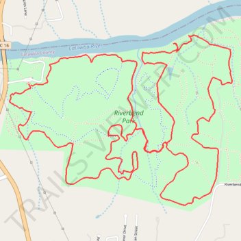
Riverbend Park Trails
- Distance: 7.9 mi
- Elevation gain: 617 ft
- Maximum elevation: 1,033 ft
- Elevation loss: 614 ft
- Minimum elevation: 850 ft
- Moving time: 1 h 32 m
- Moving speed: 5.1 mph
- Maximum speed: 8.0 mph
- Total time: 1 h 33 m
- Global speed: 5.0 mph
Interactive trail map
Make a donation
Gear up for your next adventure:
As an Amazon Associate, this site earns from qualifying purchases at no extra cost to you.
Trail profile
- Distance: 7.9 mi
- Elevation gain: 617 ft
- Maximum elevation: 1,033 ft
- Elevation loss: 614 ft
- Minimum elevation: 850 ft
- Moving time: 1 h 32 m
- Moving speed: 5.1 mph
- Maximum speed: 8.0 mph
- Total time: 1 h 33 m
- Global speed: 5.0 mph
Make a donation
Gear up for your next adventure:
As an Amazon Associate, this site earns from qualifying purchases at no extra cost to you.
About this trail
Name: Riverbend Park Trails trail, distance, elevation, map, profile, GPS track
Start: Blue Trail, Catawba County, North Carolina, United States (35.81980 -81.18794)
End: Blue Trail, Catawba County, North Carolina, United States (35.81968 -81.18773)
Coordinates: 35.81023 -81.18984 35.82362 -81.16824
Topography: Catawba County topographic map, elevation, terrain
Make a donation
Gear up for your next adventure:
As an Amazon Associate, this site earns from qualifying purchases at no extra cost to you.
Other hiking, mountain biking, running and outdoor activity trails
Click on a trail to view its statistics, map and profile.
Riverbend Park Blue Trail
United States > North Carolina > Catawba County
Distance: 4.4 mi • Elevation gain: 381 ft • Maximum elevation: 1,017 ft