Make a donation
Gear up for your next adventure:
As an Amazon Associate, this site earns from qualifying purchases at no extra cost to you.
Loop hike in Harold Parker State Forest
- Distance: 2.4 mi
- Elevation gain: 72 ft
- Maximum elevation: 184 ft
- Elevation loss: 72 ft
- Minimum elevation: 128 ft
- Moving time: 1 h 7 m
- Moving speed: 2.1 mph
- Maximum speed: 12.7 mph
- Total time: 1 h 31 m
- Global speed: 1.6 mph
Interactive trail map
Make a donation
Gear up for your next adventure:
As an Amazon Associate, this site earns from qualifying purchases at no extra cost to you.
Trail profile
- Distance: 2.4 mi
- Elevation gain: 72 ft
- Maximum elevation: 184 ft
- Elevation loss: 72 ft
- Minimum elevation: 128 ft
- Moving time: 1 h 7 m
- Moving speed: 2.1 mph
- Maximum speed: 12.7 mph
- Total time: 1 h 31 m
- Global speed: 1.6 mph
Make a donation
Gear up for your next adventure:
As an Amazon Associate, this site earns from qualifying purchases at no extra cost to you.
About this trail
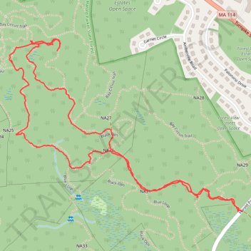
Name: Loop hike in Harold Parker State Forest trail, distance, elevation, map, profile, GPS track
Start: Stearns Pond Road, North Andover, Essex County, Massachusetts, United States (42.62550 -71.06963)
End: Harold Parker Road, North Andover, Essex County, Massachusetts, United States (42.62549 -71.06982)
Coordinates: 42.62549 -71.08121 42.63182 -71.06963
Topography: Essex County topographic map, elevation, terrain
Make a donation
Gear up for your next adventure:
As an Amazon Associate, this site earns from qualifying purchases at no extra cost to you.