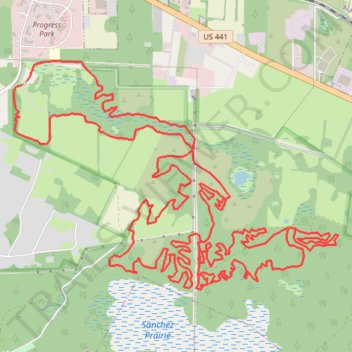
Some of the bike trails at San Felasco Preserve State Park
- Distance: 19.4 mi
- Elevation gain: 873 ft
- Maximum elevation: 187 ft
- Elevation loss: 879 ft
- Minimum elevation: 69 ft
- Moving time: 1 h 55 m
- Moving speed: 10.0 mph
- Maximum speed: 19.3 mph
- Total time: 2 h 45 m
- Global speed: 7.0 mph
Interactive trail map
Trail profile
- Distance: 19.4 mi
- Elevation gain: 873 ft
- Maximum elevation: 187 ft
- Elevation loss: 879 ft
- Minimum elevation: 69 ft
- Moving time: 1 h 55 m
- Moving speed: 10.0 mph
- Maximum speed: 19.3 mph
- Total time: 2 h 45 m
- Global speed: 7.0 mph
About this trail
Name: Some of the bike trails at San Felasco Preserve State Park trail, distance, elevation, map, profile, GPS track
Start: Cellon Creek Loop, Alachua, Alachua County, Florida, 32615, United States (29.77495 -82.47432)
End: Cellon Creek Loop, Alachua, Alachua County, Florida, 32615, United States (29.77459 -82.47485)
Coordinates: 29.75412 -82.47586 29.77697 -82.43848
Topography: Alachua County topographic map, elevation, terrain